| | SUMO Air Space
Issue No.16
| |
| | Worried about potential Sinkholes?
| |
|
| | The latest from SUMO GeoSurveys, providing a range of aerial and geospatial surveys using drones, known commercially as UAS (Unmanned Aircraft Systems).
To explore our full range of drone surveys, click here. | |
|
| | You need a Solution Feature Survey with Drone Multispectral | |
| | With the ability to survey large areas of land in a short period of time, Drone Multispectral Surveys provide a timely and cost-effective method for identifying potential solution features, which could lead to the formation of sink holes.
| |
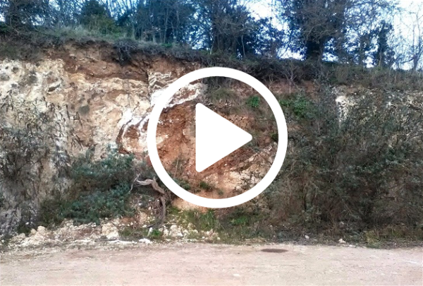
| | Above: Video of a solution feature cut into the chalk bedrock. | |
| | The multispectral sensor collects images at different wavelengths which are influenced by the health and density of the vegetation on the ground. Sub-surface anomalies, such as solution features, affect the characteristics of the overlying vegetation, and this can be identified in the multispectral data. | |
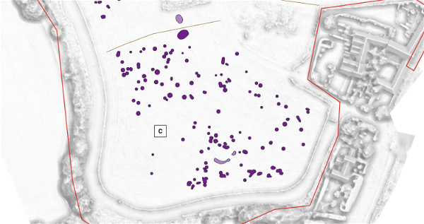
| | Above: Interpretation figure showing multispectral anomalies which can be targeted with further ground investigations. | |
| | Fast Results to Target Geophysics | |
| | With the ability to survey huge areas in a short space of time, drones serve as a perfect reconnaissance tool to target features for additional ground investigations, using other specialist geophysical techniques and equipment such as Ground Penetrating Radar (GPR).
This method provides a fast, cost-effective and informative approach to identifying solution features.
| |
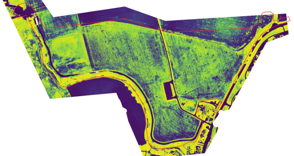
| | Above: Multispectral output from a drone solution feature survey showing health and density variations in the vegetation. | |
| | Please pick up the phone and speak to
Simon Batsman on
| |
|
| | Why not check out all the survey services available from SUMO?
| |
| | AERIAL SURVEYS
| | ARCHAEOLOGICAL
SURVEYS
| | GEOPHYSICAL
ENGINEERING
| | LASER SCANNING
& 3D | |
| | MEASURED BUILDING | | RAIL
SURVEYS
| | TOPOGRAPHIC SURVEYS
| | UTILITY
SURVEYS
| |
| | The SUMO Group is a multi-disciplinary survey business committed to maintaining the highest possible standards in all aspects of surveying. Whatever service you use, we pride ourselves on providing a survey that you can truly rely on.
| |
|
| | Interested in selling your survey business to SUMO? | |
|
| | Download our E-Brochure to find out how else we can help. | |
|
|